MWV data set
The MWV data set is unfortunately not clearly defined, and different manufacturers display the rate differently. You can also find both definitions on the internet. I myself do not know what the National Marine Electronics Association (NMEA) officially wanted in the MWV data set. Example:$WIMWV,109.50,R,5.57,N,A*29
| Field | Description | Problem |
|---|---|---|
| $WIMWV | Type definition | - |
| 109.50 | Wing direction in degrees | Unclear against what. Against the north, or against the bow? |
| R | R = Relative, T = True | Is R = Relative the apparent wind or does it mean that the wind is relative to the bow? Is T = True the True Wind or does it mean relative to North? |
| 5.57 | Wind speed | - |
| N | Unit wind speed | - |
| A*29 | Status and checksum | - |
Actual situation in version 2.59
How the logbook app edits the MWV data record
The path is different depending on whether the MWV data record contains a T or a R.T (True)
| NMEA input | Saved in the database | Explanation |
|---|---|---|
| 109.50 | 109° | The wind direction is rounded by removing the decimal places. For example 109.90° = 109°. And the wind speed may be converted from kmh or miles to knots and then transferred to the database. |
| 5.57 | 5.57 knots (display may be rounded) |
R (Relative)
| NMEA input | Saved in the database | Explanation |
|---|---|---|
| 109.50 | 289° |
The wind direction is calculated with the COG (course over ground from the last RMC data set received).
For example, the course over ground (COG) is 180°: The wind comes from 109.5° relative to the bow and the bow points directly to 180° south. So the wind comes from 289.5° (rounded 289°) |
| 5.57 | 5.57 knots (display may be rounded) |
Situation (planned) from version 2.60
You can set whether the values are relative to North or to Bug.T (True = True wind) - Values relative to North
| NMEA input | Saved in the database | Explanation |
|---|---|---|
| 109.50 | 110° | The wind direction is rounded. For example 109.50° = 110°. And the wind speed may be converted from kmh or miles to knots and then transferred to the database. |
| 5.57 | 5.57 knots (display may be rounded) |
T (True = true wind) - values relative to the bug
| NMEA input | Saved in the database | Explanation |
|---|---|---|
| 109.50 | 290° |
The wind direction is calculated with the COG (course over ground from the last RMC data set received).
For example, the course over ground (COG) is 180°: The wind comes from 109.5° relative to the bow and the bow points directly to 180° south. So the wind comes from 289.5° (rounded 290°) |
| 5.57 | 5.57 knots (display may be rounded) |
R (Relative = apparent wind) - values relative to North
| NMEA input | Saved in the database | Explanation |
|---|---|---|
| 109.50 | 063° |
The wind direction is calculated with the COG and SOG (speed and course over ground from the last received RMC data set).
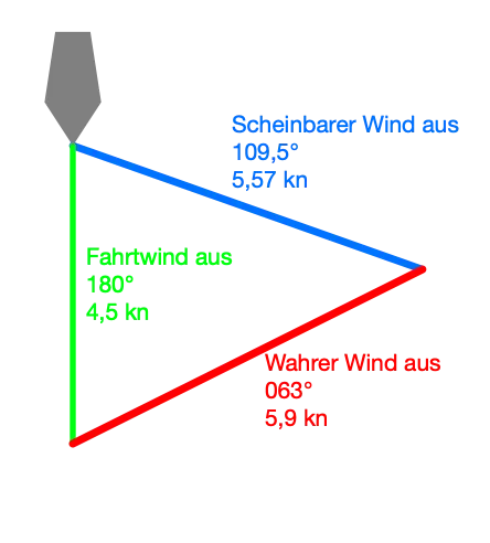
For example: Apparent wind from 109.5° with 5.57kn, sailing wind from 180° with 4.5kn (sailing with 4.5kn (SOG) direction S (COG)).
This results in the following triangle and a true wind of 5.9kn from 063° which ends up in the database.
|
| 5.57 | 5.9 knots (display may be rounded) |
R (Relative = apparent wind) - values relative to the bug
| NMEA input | Saved in the database | Explanation |
|---|---|---|
| 109.50 | 321° |
First, the wind direction from the NMEA data set is corrected by the COG (course over ground from the last RMC data set received),
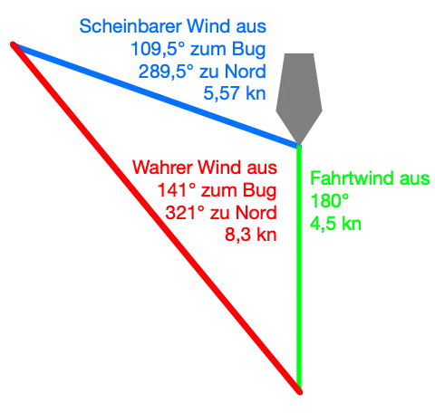
and then calculated in the same way as in the previous table. So 109.5° from the bow + 180° COG = 289.5° from north. This apparent wind from 289.5° is then converted back to a true wind.
converted to a true wind. For example: Apparent wind from 289.5° at 5.57 knots, airstream from 180° at 4.5 knots (sailing at 4.5 knots (SOG) towards S (COG)).
This results in the following triangle and a true wind of 8.3kn from 321° which ends up in the database.
|
| 5.57 | 8.3 knots (display may be rounded) |