| Tab in the app | What's already working | What's still missing |
|---|
| 1st log |
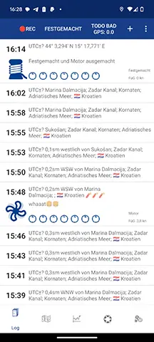
- Start autorecording
- Change status
- Create entry
- GPS position and accuracy
- App bar even more finished ;-) (Auto-recording can be started and stopped by tapping on the GPS position
|
- Search and filter function
|
| 1st log > entry |
- All values are displayed
- You can delete an entry
- Edit time, time zone, position text, KÜG, FÜG, water depth, status (sailing, anchor, etc.), engine operating hours, log, free text, weather condition, air pressure, temperature, wind direction
- Add photo to the entry
- Change between manual/auto entry
- Edit position coordinates, wind speed, cloud cover, water temperature, wave height, precipitation
|
- Resources (fresh water, fuel, etc) and database operations (maintenance entries)
|
| 2nd map |
- The trip is displayed
- You can zoom in on the trip with one click
- Open sea map overlay
- Switch between satellite and normal map
- Display of own position and possibility to zoom in there
|
- Filter by days
- Color the track by speed or status
- Tap on the track to get to the entry
|
| 3rd statistics |
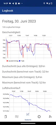
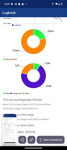
- Everything works, now the charts are also more beautiful, there was an error before.
|
- except the export as text
|
| 4. auxiliary tools |
- Export as CSV, GPX, KML
is possible.
|
- Export as PDF
- Deletion of multiple entries
- Signing of due maintenance
|
| 5th settings |
- Contact support (i.e. me)
- Settings for auto-recording (after how many nautical miles/time) an entry should be created
- Create and change logbooks
- Change units (nautical miles or kilometers, feet or meters, etc.)
- Configure and use the logbook sync
- Select data sources (still without NMEA, even if it can already be selected)
|
- Start automatic recording from here too, in case someone can't find the button with the GPS position in the log tab
|
| Features in general (no separate tab) |
- Weather is loaded from the Internet
- Geocoding: e.g. 2 NM east of Marina XY
- Logbook Sync (also to and from iOS)
|
|
| Tab in the app | What's already working | What's still missing |
|---|
| 1st log |
- Start autorecording
- Change status
- Create entry
- GPS position and accuracy
- App bar ready
|
- Search and filter function
|
| 1st log > entry |
- All values are displayed
- You can delete an entry
- Edit time, time zone, position text, KÜG, FÜG, water depth, status (sailing, anchor, etc.), engine operating hours, log, free text, weather condition, air pressure, temperature, wind direction
- Add photo to the entry
- Change between manual/auto entry
|
- Edit position coordinates, wind speed, cloud cover, water temperature, wave height, precipitation and resources (fresh water, fuel, etc)
|
| 2nd map |
- The trip is displayed
- You can zoom in on the trip with one click
- Open sea map overlay
- Switch between satellite and normal map
- Display of own position and possibility to zoom in there
|
- Filter by days
- Color the track by speed or status
- Tap on the track to get to the entry
|
| 3rd statistics |
|
- except the export as text
|
| 4. auxiliary tools |
- Export as CSV is possible (but this is still possible in the Log tab in the Debug menu)
|
- Everything else is still missing, so also the export as PDF
|
| 5th settings |
- Contact support (i.e. me)
- Settings for auto-recording (after how many nautical miles/time) an entry should be created
- Create and change logbooks
- Change units (nautical miles or kilometers, feet or meters, etc.)
- Select data sources (still without NMEA, even if it can already be selected)
|
- Everything else is still missing
|
| Features in general (no separate tab) |
- Weather is loaded from the Internet
- Geocoding: e.g. 2 NM east of Marina XY
|
|
| Tab in the app | What's already working | What's still missing |
|---|
| 1st log |
- Start autorecording
- Change status
- Create entry
- GPS position and accuracy
|
- UI finalization, partly still dummy icons, and also the app bar at the top is not yet final designed
- Search and filter function
|
| 1st log > entry |
- All values are displayed
- You can delete an entry
- Free text editable
- Item text editable
- Add photo to entry
- Change between manual/auto entry
|
- All other values (e.g. position, weather, tank contents, etc.) cannot yet be edited
- UI finalization
|
| 2nd card |
- The trip is displayed
- You can zoom in on the trip with one click
- Open sea map overlay
- Switch between satellite and normal map
|
- Filter by days
- Color the track by speed or status
- Tap on the track to get to the entry
|
| 3rd statistics |
|
- except the export as text
|
| 4. auxiliary tools |
- Export as CSV is possible (but this is still possible in the Log tab in the Debug menu)
|
- Everything else is still missing, so also the export as PDF
|
| 5th settings |
- Contact support (i.e. me)
- Settings for auto-recording (after how many nautical miles/time) an entry should be created
- Create and change logbooks
- Change units (nautical miles or kilometers, feet or meters, etc.)
|
- Everything else is still missing
|
| Features in general (no separate tab) |
- Weather is loaded from the Internet
- Geocoding: e.g. 2 NM east of Marina XY
|
|


